HUMMINBIRD® BASEMAP GETS ANGLERS FISHING, RIGHT OUT OF THE BOX
The Humminbird® Basemap provides contour maps for the U.S. coasts and 10,000+ inland lakes – including navigational aids, points of interest and other must-have features

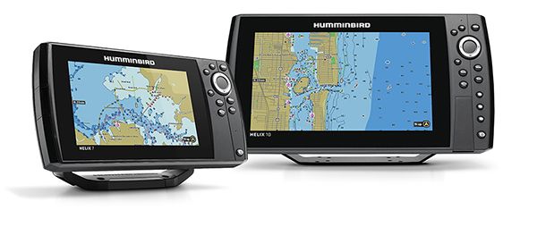
Racine, Wisconsin (7/6/2017) – The moment anglers press the power button on any Humminbird® HELIX G2 or G2N (networking) unit with GPS, they will now have access to the new Humminbird Basemap, a vast, pre-loaded coastal and lake map resource built into all units.
According to Humminbird Brand Manager Ray Schaffart, “We wanted to make it easier for anglers to navigate and start catching more fish the second they hit the water. By improving our cartography coverage with Humminbird Basemap, they’ll be able to locate fish-holding structure and experience more successful fishing adventures. Saltwater anglers will also appreciate the technology, which calls out hazards and depths, making for a more relaxed time on the water.”
The Humminbird Basemap helps anglers pinpoint fishing hot spots by showing freshwater depth contours in 10- and 20-foot increments for more than 10,000 American lakes, not to mention precise coverage of the entire U.S. coastline thanks to NOAA-based charts, the most trusted source of coastal data. The Basemap also includes navigational aids, marker buoys, depths, points of interest and launch locations to improve the boating experience. In addition to the pre-loaded lakes with contour mapping, the Humminbird Basemap provides shoreline-only maps to hundreds of thousands of other lakes. It also displays highways, roads, railroads, bike paths, and streams, along with more than 200 icons.
To support consumers who recently purchased a HELIX G2 or G2N GPS model, or any first generation HELIX 9, 10 or 12 model, the Humminbird Basemap will be available as a free software download. Consumers will need to visit Humminbird.com to set-up – or log into – their MyHumminbird account. Once logged in, they can download the software for their applicable model(s). Another advantage of the Humminbird Basemap is that it is updatable, so future enhancements and expansions will be made available.
“Humminbird is the leader in providing complete fish-finding solutions, whether on a lake or on the coast,” Schaffart says. “The Humminbird Basemap is yet another innovative way we improve the angling experience every day.”
The Humminbird Basemap will now be included on all HELIX G2/G2N GPS models beginning in July 2017. It will also be available on all SOLIX models this Fall.
For more information, call Humminbird at 800-633-1468 or visit www.Humminbird.com/Humminbird-Basemap.

For more information, please visit Humminbird at www.humminbird.com.
Requests for product specifications, customer support and general inquiries should be made through our Customer Service Department.
For media/editorial inquiries, please contact:
Heather Miller
Gunpowder, Inc.
Email Heather
Johnson Outdoors Marine Electronics, Inc. consists of the Humminbird, LakeMaster, Minn Kota and Cannon brands. Humminbird® is a leading innovator and manufacturer of fishfinders, fishfinder/GPS combo units, ice flashers and digital depth gauges. LakeMaster® is the premier brand of high-definition electronic fishing charts. Minn Kota® is the world’s leading manufacturer of electric trolling motors, as well as offers a complete line of shallow water anchors, battery chargers and marine accessories. Cannon® is the leader in controlled-depth fishing and includes a full line of downrigger products and accessories.