


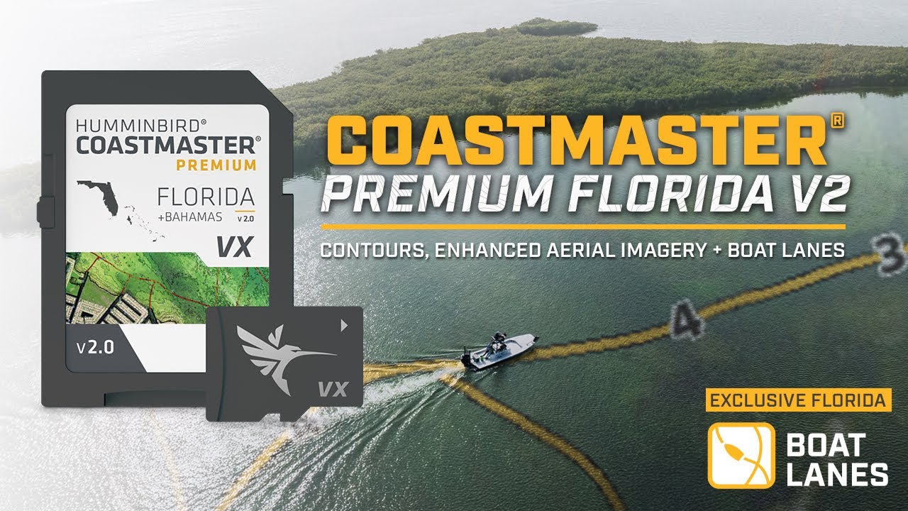


CoastMaster Premium Florida V2 with Bahamas
Item #
602014-2
$599.99
WARNING: Important information for California residents.
Overview
Humminbird® CoastMaster® Premium Florida V2 with Bahamas provides highly accurate chart coverage for all Florida waters. It also includes boat lanes for Florida and contours for the Bahamas. From easy-to-read contours to highlighted depth ranges, you'll have the tools you need to identify the spots you know will hold fish, and navigate there safely.
FEATURES
- Compatible With
- All SOLIX® G3 units, all APEX™ units and all XPLORE™ units
- Highly Accurate Chart Coverage
- Find the path to your next big catch with the incredible accuracy and detail of Humminbird® CoastMaster® Premium, Florida V2 providing highly accurate chart coverage for all Florida waters and Bahamas. From easy-to-read contours to highlighted depth ranges, you'll have the tools you need to identify the spots you know hold fish.
- Boat Lanes for Your Route
- Includes Florida Boat Lanes with tracks labeled with actual depth to plan your route to elusive fishing holes. With a safety depth feature that customizes tracks to your boat’s draft, highlighting shallow areas in red to avoid hazards.
- Includes Bahamas and Keys
- Includes Bahamas with exclusive shallow water contours and shaded relief and high-definition shaded relief for the Keys and other highly fished areas.
- 2D Shaded Relief
- This layer helps make bottom detail and depth changes easy to spot.
- Enhanced Aerial Imagery
- Provides crystal-clear water visibility, perfect for scouting new fishing holes.
- Bottom Hardness
- The Bottom Hardness layer helps anglers identify bottom composition and key fish-holding areas.
- Tides and Currents
- Using predictive software, CoastMaster allows you to plan your fishing day with tidal direction and height, as well as the speed and direction of currents and more, so you’ll never be caught guessing.
- Shallow Water Highlight
- Identify shallow water areas on an adjustable range from zero to 30 feet.
- Water Level Adjustments
- Synchronize the depth contours and shorelines of your CoastMaster charts with the actual water levels, so that your chart will reflect the current water level of your fishing spots.
SPECS
| General | |
| Model | CoastMaster Premium Florida V2 with Bahamas |
| Product Code | 602014-2 |
| UPC | 0082324057984 |
| Region | Florida (Coastal), Bahamas |
| Warranty | One-Year Warranty |
| Technical Details | |
| Delivery | SD Card |
| Product Type | CoastMaster |
RESOURCES & SUPPORT
WHY YOU'LL LOVE IT

Includes Boat Lanes
Boat Lane tracks are labeled with actual depth allowing you to confidently plan your route to those elusive fishing holes. Also included is a safety depth feature that customizes to your boat’s draft, highlighting shallow area in red to avoid hazards.

2D Shaded Relief
Makes bottom detail and depth changes easy to spot; this includes high-definition shaded relief for the Keys.

Enhanced Aerial Imagery
Stunning 6” high-resolution imagery covers much of Florida’s most popular waters; with enhanced imagery providing crystal-clear water visibility, perfect for scouting new fishing holes.

Depth Highlights
Create up to four user-defined depth highlight ranges, so you can easily target productive water and stay in the bite zone.


